Concord Pacific Place is a 200-acre project adjacent Vancouver’s urban centre. This was
the site of Expo 86. In 1988, Concord Pacific Developments Ltd. purchased the site and
appointed a consortium of three local architectural firms; Hulbert Group, Davidson Yuen
Simpson and Downs Archambault, along with the landscape architectural firm of Don

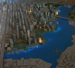
The site model being discussed by Stanley Kwak, Pres. Concord Pacific Developments Ltd. and Don Vaughan
Vaughan Ltd. to begin the planning. The original concept of the Lagoons was inspired by Rick Hulbert and it received great public aclaim, but did not receive approval from the city. After several attempts to resolve the city’s concerns Stanley met with the City Manager and asked what he would have to do to get the project moving forward he was told; “You have created a great project, now try to create a project that will make this a great city.”
The Guiding Principles that Stanley was given at that meeting were:
. Keep the existing shoreline as it is.
. Extend the street grid through the project
. Place the towers to align with the streets.
. Give parks a priority on the waterfront.
Stanley came back to the design team and told us we had two weeks to create several new schemes. He asked us to break into individual groups with each architect and Don to lead the teams. Davidson Yuen chose to manage the process leaving three teams; Hulbert Group, Downs Archambualt and Don Vaughan Ltd. After the two weeks we all gathered in the board room with the drawings posted on the walls. Hick Hulbert led off with a plan of axial views and connections . Barry Downs followed with three concepts, ‘Urban/Coastal, Urban/Urban and Coastal/ Coastal. I then presented my plan that used the parks and open space to reinforce the bays along the shoreline. I called this the “Bays Scheme”. This responded to the concept that Paul Merrick had used many years earlier for South False Creek across the water. That concept when applied here at the Concord site put the buildings on the peninsulas, allowing each building to either be on the Seawall Walk or across the park with unobstructed views of the water.
Stanley Kwok, President of Concord Pacific Developments Ltd, provided the lead role in the planning and design. He, selected the “Bays Scheme”. This was the plan that I and the rest of the Design Team would go on to develop. We worked closely with Vancouver Planning Department, Engineering Department and the Park Board in finalizing the OCP.
 The Bays Scheme responded to the City’s guidelines. Existing bays were reinforced with minor changes to the water edge. The parks were primairly at the water’s edges extended back into the City to reinforce the open space of the bays. The City street grid was extended through the site with the street end views terminating in special waterfront parks and public art.
In addition to the City’s Guiding Principles the plan used the built form of the residential development to anchor the headlands and further contain the bays and parks. The parks are linked along the entire 2-mile waterfront with a 32-foot wide pedestrian and bicycle path system.
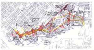
The OCP required that the parks and the open space including the Seawall walk were designed in sufficient detail to provide a clear programmed spaces for the design in the following individual ADPs. In a project of this size I felt it was important to create variety and spaces of individual character. To do this the walk would not always be at the waters edge. So, the walkway varies both away from the edge at various locations, but also moves up and down creating variety. To assure this the OCP drawing would include a parks plan for all of the parks describing the character and detailed design.
The first park to be developed was Andy Livingston Park with its artificial play field, two tennis courts, a major playground next to the future school and a small plaza as an entry to the park from its Chinatown side. To satisfy the School requirement that the entire park space be accessible without crossing the street, a land bridge was added to the design.
The second park was David Lam Park. It was to be the “Village Green” for the project. It was to have a playfield as its major focus.
The third park was the along the waterfront on both sides of the Cambie Bridge. This is a narrow park with a major part along the waterfront. In this location the water moving rapidly between the bridge abutments as the tide changes was an ideal location to create the opposite from the open lawn of the Village Green. Here the plan proposed a natural landscape of conifer forests along side the bridge and a variety af native landscapes for the waters edge of the park. To the north of the bridge there would be an open lawn area. The area under the bridge was to be designed for use during the rain. Using Expo ‘86’s child play area as an example.
The most westerly park was designed to be a strong formal place at the visual terminus of Richards Street. The plan showed a major fountain. The park would also include further sports courts.
The last park is located at the far eastern end of the creek was meant to compliment Andy Livingston Park with additional sports facilities. This northeastern end of the project borders on the commercial uses of Chinatown and is more compatible with the activity of sports, noise and night lighting than it would be next to the housing.
return to Urban Design and Planning
go to Roundhouse Neighbourhood

